Article
Quttinirpaaq National Park
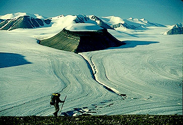
Quttinirpaaq National Park (established 1988, 37 775 km2) is Canada's second-largest national park (after Wood Buffalo National Park).
Signing up enhances your TCE experience with the ability to save items to your personal reading list, and access the interactive map.
Create AccountArticle
Quttinirpaaq National Park (established 1988, 37 775 km2) is Canada's second-largest national park (after Wood Buffalo National Park).
"https://d3d0lqu00lnqvz.cloudfront.net/media/media/5176d9ce-bf5f-4fdf-9453-c0f71b3128e6.jpg" // resources/views/front/categories/view.blade.phphttps://d3d0lqu00lnqvz.cloudfront.net/media/media/5176d9ce-bf5f-4fdf-9453-c0f71b3128e6.jpg
Article
More familiar are the "road stations" built between 1855 and 1857 for the Grand Trunk Railway's line from Montréal to Toronto and Sarnia.
"https://d3d0lqu00lnqvz.cloudfront.net/media/media/10107a9f-701b-469d-83d4-c13b79c50b3e.jpg" // resources/views/front/categories/view.blade.phphttps://d3d0lqu00lnqvz.cloudfront.net/media/media/10107a9f-701b-469d-83d4-c13b79c50b3e.jpg

Article
Railways, Track and Yards Railway track is the assembly of the 5 basic components - rail, ties, fastenings, ballasts and subgrade - over which trains run. Rails are rolled steel lengths bolted or welded together to form the running surface for trains.
"https://www.thecanadianencyclopedia.ca/images/tce_placeholder.jpg?v=e9dca980c9bdb3aa11e832e7ea94f5d9" // resources/views/front/categories/view.blade.phphttps://www.thecanadianencyclopedia.ca/images/tce_placeholder.jpg?v=e9dca980c9bdb3aa11e832e7ea94f5d9

Article
Rainbow Stage, named for its rainbow-shaped proscenium arch, opened with a variety show directed by Duncan on 7 July 1954. In September 1955 Duncan directed the first musical comedy performed there, Brigadoon, which marked the beginning of a tradition.
"https://d3d0lqu00lnqvz.cloudfront.net/media/media/9654eb74-30b7-4494-8deb-089276f161cf.jpg" // resources/views/front/categories/view.blade.phphttps://d3d0lqu00lnqvz.cloudfront.net/media/media/9654eb74-30b7-4494-8deb-089276f161cf.jpg

Article
After several seasons of poor weather a triodetic dome was constructed over the theatre in 1970.
"https://d3d0lqu00lnqvz.cloudfront.net/media/media/9654eb74-30b7-4494-8deb-089276f161cf.jpg" // resources/views/front/categories/view.blade.phphttps://d3d0lqu00lnqvz.cloudfront.net/media/media/9654eb74-30b7-4494-8deb-089276f161cf.jpg
Article
Rainy Lake, 932 km2 (741 km2 in Canada), elev 338 m, is located in rough woodlands astride the Ont-Minn border, 240 km W of Lk Superior. It discharges into the Rainy R, which flows W along the border to LK OF THE WOODS.
"https://www.thecanadianencyclopedia.ca/images/tce_placeholder.jpg?v=e9dca980c9bdb3aa11e832e7ea94f5d9" // resources/views/front/categories/view.blade.phphttps://www.thecanadianencyclopedia.ca/images/tce_placeholder.jpg?v=e9dca980c9bdb3aa11e832e7ea94f5d9
Article
The Rainy River Burial Mounds archaeological sites are located on the Canadian bank of the Rainy River in Ontario.
"https://www.thecanadianencyclopedia.ca/images/tce_placeholder.jpg?v=e9dca980c9bdb3aa11e832e7ea94f5d9" // resources/views/front/categories/view.blade.phphttps://www.thecanadianencyclopedia.ca/images/tce_placeholder.jpg?v=e9dca980c9bdb3aa11e832e7ea94f5d9
Article
Random Island, NL, 249 km2 is the second largest island off the Island of Newfoundland (FOGO ISLAND is larger at 254 km2). Random Island runs 40 km east-west and 14 km north-south, and is situated in a deep western indentation of TRINITY BAY.
"https://www.thecanadianencyclopedia.ca/images/tce_placeholder.jpg?v=e9dca980c9bdb3aa11e832e7ea94f5d9" // resources/views/front/categories/view.blade.phphttps://www.thecanadianencyclopedia.ca/images/tce_placeholder.jpg?v=e9dca980c9bdb3aa11e832e7ea94f5d9
Article
The Rat Indian Creek site is located above the Arctic Circle, on the Porcupine River, 60 km east of the Vuntut Gwitchin village of Old Crow, Yukon.
"https://d3d0lqu00lnqvz.cloudfront.net/media/media/891e3d37-3191-4b19-900a-76e3eb2be918.jpg" // resources/views/front/categories/view.blade.phphttps://d3d0lqu00lnqvz.cloudfront.net/media/media/891e3d37-3191-4b19-900a-76e3eb2be918.jpg

Article
Raymond, Alberta, incorporated as a town in 1903, population 3,708 (2016 census), 3,743 (2011 census). The town of Raymond is located in southern Alberta, approximately 35 km south of Lethbridge. In the early 1900s the area was settled by Mormons and Japanese labourers (see also Japanese Canadians). The Raymond Stampede, Canada’s first rodeo, has been held in the town since 1902.
"https://d3d0lqu00lnqvz.cloudfront.net/media/media/073c1dc8-391d-4239-808d-814a185846c0.jpg" // resources/views/front/categories/view.blade.phphttps://d3d0lqu00lnqvz.cloudfront.net/media/media/073c1dc8-391d-4239-808d-814a185846c0.jpg

Article
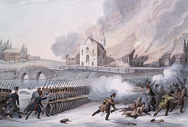
In 1837 and 1838, French Canadian militants in Lower Canada took up arms against the British Crown in a pair of insurrections. The twin rebellions killed more than 300 people. They followed years of tensions between the colony’s anglophone minority and the growing, nationalistic aspirations of its francophone majority. The rebels failed in their campaign against British rule. However, their revolt led to political reform, including the unified Province of Canada and the introduction of responsible government. The rebellion in Lower Canada, which is also known as the Patriots' War (la Guerre des patriotes), also gave French Canadians one of their first nationalist heroes in Louis-Joseph Papineau.
"https://d3d0lqu00lnqvz.cloudfront.net/media/media/37aadc48-3f88-4946-a9aa-0d2ad30495cd.jpg" // resources/views/front/categories/view.blade.phphttps://d3d0lqu00lnqvz.cloudfront.net/media/media/37aadc48-3f88-4946-a9aa-0d2ad30495cd.jpg
Article
The 1837 rebellion in Upper Canada was a less violent, more limited affair than the uprising earlier that year in Lower Canada. However, its leaders, including William Lyon Mackenzie, were equally serious in their demands. They wanted democratic reform and an end to the rule of a privileged oligarchy. The rebellion itself failed, but its very failure helped pave the way for moderate and careful political change in British North America. This included the union of Upper and Lower Canada into the Province of Canada and the eventual introduction of responsible government.
"https://d3d0lqu00lnqvz.cloudfront.net/media/media/e89570fd-5967-4c63-906b-bfbfab2e39fb.jpg" // resources/views/front/categories/view.blade.phphttps://d3d0lqu00lnqvz.cloudfront.net/media/media/e89570fd-5967-4c63-906b-bfbfab2e39fb.jpg

Article
Red Bay, NL, incorporated as a town in 1997, population 169 (2016 census), 194 (2011 census). The town of Red Bay is located on the Strait of Belle Isle, off Labrador’s south coast. Named for its prominent red cliffs, it was one of two major Basque whaling stations established in the 1540s. After research into Spanish documents and archaeological finds on Saddle Island and under water, Red Bay was designated a historical site in 1978-79 (see Red Bay Archaeological Site). In 2013, the whaling station at Red Bay was designated a UNESCO World Heritage Site.
"https://d3d0lqu00lnqvz.cloudfront.net/media/media/2d045c80-3539-44a1-a87c-7b1a734b8c91.jpg" // resources/views/front/categories/view.blade.phphttps://d3d0lqu00lnqvz.cloudfront.net/media/media/2d045c80-3539-44a1-a87c-7b1a734b8c91.jpg

Article
Red Bay, located on the north shore of the Strait of Belle Isle, Labrador, is an archaeological reference for the 16th-century transatlantic fishery, particularly for Basque whaling activities. After research into Spanish documents and archaeological finds on Saddle Island and under water, Red Bay was designated a historical site in 1978-79. In 2013, the whaling station at Red Bay was designated a UNESCO World Heritage Site.
"https://d3d0lqu00lnqvz.cloudfront.net/media/media/2d045c80-3539-44a1-a87c-7b1a734b8c91.jpg" // resources/views/front/categories/view.blade.phphttps://d3d0lqu00lnqvz.cloudfront.net/media/media/2d045c80-3539-44a1-a87c-7b1a734b8c91.jpg
Article
Red Deer, Alberta, incorporated as a city in 1913, population 100,844 (2021 census), 100,418 (2016 census). The city of Red Deer is located on the Red Deer River, 150 km south of Edmonton. The Cree applied the name “Elk” to the river, but Scottish fur traders appear to have confused elk with the red deer of their homeland.
"https://www.thecanadianencyclopedia.ca/images/tce_placeholder.jpg?v=e9dca980c9bdb3aa11e832e7ea94f5d9" // resources/views/front/categories/view.blade.phphttps://www.thecanadianencyclopedia.ca/images/tce_placeholder.jpg?v=e9dca980c9bdb3aa11e832e7ea94f5d9