National parks | The Canadian Encyclopedia

Browse "National parks"

Displaying 16-30 of 46 results
  • Article

    Ivvavik National Park

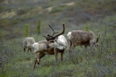
    Initially known as Northern Yukon National Park, it was given an Inuvialuit name in 1992. Ivvavik means "place of giving birth and raising young" in reference to the Porcupine Caribou herd that has its calving grounds along the Beaufort Sea coast.

    "https://d3d0lqu00lnqvz.cloudfront.net/media/media/ba702448-1511-48f9-b516-fe8723fbb166.jpg" // resources/views/front/categories/view.blade.php
    
    https://d3d0lqu00lnqvz.cloudfront.net/media/media/ba702448-1511-48f9-b516-fe8723fbb166.jpg Ivvavik National Park
  • Article

    Jasper National Park

    Jasper National Park is a protected area located in the Rocky Mountains, about 370 km west of Edmonton, Alberta. Established in 1907, it was the fifth national park created in Canada. It’s also one of seven parks in the Rocky Mountains that make up the Canadian Rocky Mountain Parks UNESCO World Heritage site (the others are Yoho, Banff and Kootenay national parks, and Mount Robson, Mount Assiniboine and Hamber provincial parks). Among the reasons for the UNESCO designation are the parks’ mountain landscapes, complete with waterfalls, canyons and glaciers, including those found in the Columbia Icefield.

    "https://d3d0lqu00lnqvz.cloudfront.net/media/Twitter_Cards/jasper.jpg" // resources/views/front/categories/view.blade.php
    
    https://d3d0lqu00lnqvz.cloudfront.net/media/Twitter_Cards/jasper.jpg Jasper National Park
  • Article

    Kejimkujik National Park and National Historic Site

    The wildlife is diverse. The park's marshes, bogs and shallow lakes support more species of reptiles and amphibians than occur anywhere else in Atlantic Canada, including such rarities as the ribbon snake and Blanding's turtle.

    "https://www.thecanadianencyclopedia.ca/images/tce_placeholder.jpg?v=e9dca980c9bdb3aa11e832e7ea94f5d9" // resources/views/front/categories/view.blade.php
    
    https://www.thecanadianencyclopedia.ca/images/tce_placeholder.jpg?v=e9dca980c9bdb3aa11e832e7ea94f5d9 Kejimkujik National Park and National Historic Site
  • Article

    Kluane National Park and Reserve

    Kluane National Park and Reserve (established 1976, 21,980 km2) is an area of unclimbed peaks, vast ice fields, clear lakes, glaciers and spectacular wildlife. Tucked in the southwest corner of the Yukon Territory, 150 km west of Whitehorse, Kluane (pronounced kloo-AH-nee) contains Canada’s highest peak, Mount Logan. It is named after Yukon’s largest lake, which borders the park. The park and park reserve, together with Tatshenshini-Alsek Wilderness Provincial Park in British Columbia and Glacier Bay and Wrangell-St. Elias national parks in Alaska, form an international UNESCO World Heritage Site covering over 98,391 km2.

    "https://d3d0lqu00lnqvz.cloudfront.net/media/media/eaf72296-f152-4658-8249-bbf7a8b70296.jpg" // resources/views/front/categories/view.blade.php
    
    https://d3d0lqu00lnqvz.cloudfront.net/media/media/eaf72296-f152-4658-8249-bbf7a8b70296.jpg Kluane National Park and Reserve
  • Article

    Kootenay National Park

    Kootenay National Park (established 1920, 1406.4 km2) is located on the west slope of the Continental Divide. The park, stretching north and south for 104 km, is bounded on the east by Banff and Mount Assiniboine Provincial Park on the north by Yoho National Park.

    "https://d3d0lqu00lnqvz.cloudfront.net/media/media/1aa8fafc-a0a0-48c9-86a8-6e588b13ecfe.jpg" // resources/views/front/categories/view.blade.php
    
    https://d3d0lqu00lnqvz.cloudfront.net/media/media/1aa8fafc-a0a0-48c9-86a8-6e588b13ecfe.jpg Kootenay National Park
  • Article

    Kouchibouguac National Park

    Piping plovers, an endangered species, and common terns nest on the beaches and barrier islands. Striped bass spawn in the estuaries. Much of the park has been logged and farmed in the past, and accordingly, much of the forest is in an early successional stage.

    "https://d3d0lqu00lnqvz.cloudfront.net/media/media/e97c45cd-3a4a-4ac7-a6b5-36fb870661c5.jpg" // resources/views/front/categories/view.blade.php
    
    https://d3d0lqu00lnqvz.cloudfront.net/media/media/e97c45cd-3a4a-4ac7-a6b5-36fb870661c5.jpg Kouchibouguac National Park
  • Article

    La Mauricie National Park

    La Mauricie National Park (est 1977, 536.1 km2), first set aside in 1970, is situated about 220 km northeast of Montréal.

    "https://d3d0lqu00lnqvz.cloudfront.net/media/media/3996aa5e-19b5-4483-b7b5-84ce22f09502.jpg" // resources/views/front/categories/view.blade.php
    
    https://d3d0lqu00lnqvz.cloudfront.net/media/media/3996aa5e-19b5-4483-b7b5-84ce22f09502.jpg La Mauricie National Park
  • Article

    Mount Revelstoke National Park

    Mount Revelstoke is generally acknowledged as the birthplace of alpine skiing in Canada, and it was established, in part, because of its recreational potential. Today cross-country skiing and snowshoeing are popular winter activities. The park offers primitive backcountry campsites.

    "https://d3d0lqu00lnqvz.cloudfront.net/media/media/d2b11ccd-0a14-4857-aafd-b31bb02c12ec.jpg" // resources/views/front/categories/view.blade.php
    
    https://d3d0lqu00lnqvz.cloudfront.net/media/media/d2b11ccd-0a14-4857-aafd-b31bb02c12ec.jpg Mount Revelstoke National Park
  • Article

    Nahanni National Park Reserve

    Nahanni National Park Reserve (est 1976, 4765.2 km2) is a wilderness of rugged mountains, wild rivers and luxurious hot springs stretched along the South Nahanni River in the southwest corner of the Northwest Territories.

    "https://d3d0lqu00lnqvz.cloudfront.net/media/media/f03ee7f1-6a31-4148-8ca4-a42264dd3a8e.jpg" // resources/views/front/categories/view.blade.php
    
    https://d3d0lqu00lnqvz.cloudfront.net/media/media/f03ee7f1-6a31-4148-8ca4-a42264dd3a8e.jpg Nahanni National Park Reserve
  • Article

    National Parks of Canada

    Canada’s national parks are protected areas established under federal legislation to preserve Canada’s natural heritage. They are administered by Parks Canada, a government agency that evolved from the world’s first national parks service, the Dominion Parks Branch, established in 1911. The National Parks System Plan, developed in 1970, divided Canada into 39 natural regions and set the goal of representing each region with at least one national park. Canada now has 48 national parks and national park reserves in 30 of these regions. In total, the parks cover more than 340,000 km2, which is over 3 per cent of Canada’s landmass. They protect important land and marine habitats, geographical features and sites of cultural significance. National parks also benefit local economies and the tourism industry in Canada. (This is the full-length entry about National Parks of Canada. For a plain-language summary, please see National Parks of Canada (Plain-Language Summary).)

    "https://d3d0lqu00lnqvz.cloudfront.net/media/media/27f9bb3e-3454-4b12-9aca-ded0299bfe8c.jpg" // resources/views/front/categories/view.blade.php
    
    https://d3d0lqu00lnqvz.cloudfront.net/media/media/27f9bb3e-3454-4b12-9aca-ded0299bfe8c.jpg National Parks of Canada
  • Article

    Nunavik

    Nunavik, the portion of land within the province of Quebec located north of the 55th parallel, covers approximately 500,000 km2 (representing more than one-third of Quebec’s territory). For approximately 4,000 years, Indigenous people have inhabited Nunavik, including Inuit who have made the region their homeland. Today, over 13,000 people live in Nunavik’s 14 villages spread along the Ungava Bay, Hudson Strait and Eastern Hudson Bay coasts.

    "https://www.thecanadianencyclopedia.ca/images/tce_placeholder.jpg?v=e9dca980c9bdb3aa11e832e7ea94f5d9" // resources/views/front/categories/view.blade.php
    
    https://www.thecanadianencyclopedia.ca/images/tce_placeholder.jpg?v=e9dca980c9bdb3aa11e832e7ea94f5d9 Nunavik
  • Article

    Pacific Rim National Park Reserve

    Pacific Rim National Park Reserve (est 1970, 285.8 km2) stretches for 105 km along the rugged west coast of Vancouver Island.

    "https://d3d0lqu00lnqvz.cloudfront.net/media/media/14e848e6-2343-4115-a5a5-78d718430c10.jpg" // resources/views/front/categories/view.blade.php
    
    https://d3d0lqu00lnqvz.cloudfront.net/media/media/14e848e6-2343-4115-a5a5-78d718430c10.jpg Pacific Rim National Park Reserve
  • Article

    Parc national de la Gaspésie

    In the heart of the ​Gaspé Peninsula​, 196 km east of Rimouski, is Parc national de la Gaspésie (established 1981, 802 km2). First established in 1937 by means of special legislation, the park has in the past bowed to mining and forestry pressures. It is now completely protected through the park's Act.

    "https://www.thecanadianencyclopedia.ca/images/tce_placeholder.jpg?v=e9dca980c9bdb3aa11e832e7ea94f5d9" // resources/views/front/categories/view.blade.php
    
    https://www.thecanadianencyclopedia.ca/images/tce_placeholder.jpg?v=e9dca980c9bdb3aa11e832e7ea94f5d9 Parc national de la Gaspésie
  • Article

    Point Pelee National Park

    Point Pelee National Park (established 1918) is a protected area at the tip of Point Pelee, a long peninsula extending into the western end of Lake Erie, south of Leamington, Ontario. Middle Island — Canada’s southernmost piece of land located southwest of Point Pelee — was added to the park in 2000. At 15 km2, Point Pelee National Park is Canada’s second smallest national park. It’s also the southernmost tip of Canada’s mainland, located further south than northern California.

    "https://d3d0lqu00lnqvz.cloudfront.net/media/new_article_images/25942993688_275b33c77b_o.jpg" // resources/views/front/categories/view.blade.php
    
    https://d3d0lqu00lnqvz.cloudfront.net/media/new_article_images/25942993688_275b33c77b_o.jpg Point Pelee National Park
  • Article

    Prince Albert National Park

    Natural Heritage Bounded to the south by farmland, the park lies on a transition zone between 2 ecoregions. Pockets of aspen parkland and fescue prairie in the south of the park blend with mixed-wood and boreal forests in the park's northern reaches.

    "https://d3d0lqu00lnqvz.cloudfront.net/media/media/f507b630-0ecd-47f8-b3a8-7ef49ed586c9.jpg" // resources/views/front/categories/view.blade.php
    
    https://d3d0lqu00lnqvz.cloudfront.net/media/media/f507b630-0ecd-47f8-b3a8-7ef49ed586c9.jpg Prince Albert National Park