Share on Facebook
 Share on X
 Share by Email
 Share on Google Classroom


In broadest terms, urban and regional planning is the process by which communities attempt to control and/or design change and development in their physical environments. It has been practised under many names: town planning, city planning, community planning, land use planning, and physical environment planning. The object of planning is the "physical environment," which is taken to mean land and all its uses, along with everything that has tangible existence on or beneath the land surface. Planning also includes the manner and style by which buildings are laid out in a city, and the design of public places.
Physical environments are partly natural and partly man-made. A satisfying man-made or "built" environment is the ultimate goal of planning, but relations between natural and built environments, and interactions between people and their environments, are also of vital concern. Human activities can have negative impacts upon the natural environment, just as certain natural conditions are hazardous to human well-being. Planners are equally concerned to protect natural environments from the adverse effects of human use (eg, water pollution), and to protect people from adverse natural circumstances (eg, flood zones).
To plan the physical environment means to impose some deliberate order upon it, with the aim of achieving a desired standard of environmental quality. Environmental quality is the heart of planning practice, although there is no universal agreement about the characteristics of a "good" or well-ordered environment. Different cultures have tended to value environmental qualities differently and to organize their environments in different ways. Many factors influence the choice of qualities that are most desired at a particular time and place. Each community, through social and political processes, must set its own standards of a good physical environment. Also, people's needs, tastes and economic circumstances influence the quality of environments that are planned and built.
A variety of issues fall within the scope of urban and regional planning, depending partly on the geographical scale of the planning area. Regional planners will be concerned with such matters as the protection of farmland or other valued resource sites (eg, forests, mineral deposits, seashores, lakeshores); the preservation of unique natural or historical features; the locations of highways and other transport facilities, such as PIPELINES or airports; and the growth prospects of communities located throughout the region. If the region is organized around a large city, the planners must also take account of the problems caused by the city's expansion, and its impact upon the surrounding countryside and nearby towns.
For cities and towns, planning issues are of 2 general kinds. First there is a need to think ahead to accommodate the city's growth - deciding which lands should be built on and when, and whether they should be used for residential development, for industry or for some more specialized function, such as a shopping centre or playing fields. Eventually, more detailed plans will also be required to determine the layout of every piece of land. The street network has to be designed; sites have to be reserved for schools and parks, shops, public buildings and religious institutions; provision has to be made for transit services and utilities; and development standards have to be set and design ideas have to be tested to ensure that the desired environmental quality is achieved.
A second group of issues concerns those parts of the community that are already developed. Planners will distinguish between areas where change is not desired and those where change is either unavoidable or judged to be needed. In the former case, the concern is for maintaining the built environment at its existing quality, regardless of pressures for change. This applies particularly to inner-city neighbourhoods which face pressures for apartment redevelopment or for streets to be widened to permit through traffic. In the latter case, the problem is to facilitate the changes that are considered most desirable. In one situation this may mean that a deteriorating area has to be upgraded; in another it may mean that buildings have to be demolished to allow their sites to be used in a new and different way. The problems of rapidly changing downtowns, of outdated industrial and warehousing districts, and of inner-city neighbourhoods experiencing a complex mix of social and physical changes all have to be dealt with by planners and public authorities. So, too, must special issues such as HERITAGE CONSERVATION, the relocation of railway tracks, the provision of rapid-transit facilities, and the special housing needs of different groups of people.
Urban environments continue to change. As cities age, it becomes more difficult and more expensive to maintain environmental quality. People's needs and desires change as well, and the built environment must be constantly adapted. Special restoration or revitalization programs may be undertaken to try to draw business back to declining shopping districts and stimulate the local economy. Yet investment funds, both public and private, are in shorter supply than in times of economic growth. The download of services from the higher levels of governments to the municipal level also competes for municipal funds.
Social and Political Foundations
Like all types of planning (eg, REGIONAL DEVELOPMENT PLANNING; NATIONAL CAPITAL COMMISSION; URBAN DESIGN), planning cities and regions finds its rationale in the belief that a controllable future offers more promise than an uncontrolled one, and that a planned environment provides better opportunities for all people to enjoy their community setting. Urban and regional planning is but one of many approaches adopted by society for achieving the security, comfort and long-term betterment of its members. This does not mean that all plans are prepared by governments, or that all planners are public servants, but it does mean that planning systems are usually designed to ensure that the needs of the entire community are properly considered. Plans come from many sources - from individuals, private corporations and public agencies - all of which have special ends or interests to pursue. In the "planned" community a higher level of forethought and public control is imposed, not to prevent these individual plans from being realized but to ensure that they harmonize with one another and with the overall needs of the community.
It is rarely possible to demonstrate that an action taken in anticipation of the future will benefit an entire community. It is also difficult to show that a single public interest can be served. More commonly, planning is a matter of trying to decide which of many competing interests is more deserving, while also trying to treat everyone in a fair and lawful manner. Should a city council allow a shopping centre to be built in a residential area? An issue like this raises questions about personal rights and freedoms, and about the powers and obligations of public authorities. Hence, the ultimate planning decisions are political decisions, since politics is society's way of settling the conflicts that arise within a community.
Planning, then, is a way by which communities determine how they would like their environment to be. What kinds of benefits can they then look forward to? Official definitions in Canada have generally responded to this question by describing planning as a type of CONSERVATION. It is aimed at the wise use and management of community resources, a critical one being land. The idea that land is both a private commodity and a community resource is controversial, but Canadian law has established that there is a legitimate community interest in the development of any land. Large amounts of public money have to be spent on such things as transport facilities, water treatment plants, schools and parks.
The community assumes most of the responsibility for ensuring that land is developed in ways that will allow these public services to function efficiently. This is taken to mean that the development of land should yield the greatest possible public benefit for the lowest possible public cost. Yet the measurement of benefits and costs is no easy matter. For example, deciding upon the best use of land on the outskirts of a city depends on estimating what values to attach to such benefits as an increase in the supply of new houses or an attractive residential environment, and how to weigh these benefits against a different set of costs, such as long journeys to work or the loss of prime agricultural land.
Origins of Planning in Canada
The close connection between conservation and urban and regional planning began with the COMMISSION OF CONSERVATION in the years before WWI. At this time, Canada was caught up in a wave of reform enthusiasm that drew its inspiration from several international sources: from British town planning, including the Garden City movement; from the progressive reform movement in the US, with its attacks on political corruption and public mismanagement of all kinds; from the housing reform movements in both countries; and from the CITY BEAUTIFUL movement, which offered the ideal of well-ordered cities, with handsome buildings and public spaces, as symbols of the progress of industrial civilization.
All across Canada, groups of citizens organized themselves into "city planning commissions" and "civic improvement leagues" (see URBAN REFORM). Yet it was not until the Commission of Conservation developed an interest in PUBLIC HEALTH that these concerns were given national prominence. The commission viewed the health of the people as the greatest of all resources. Town planning, as it was then called, was thought to be one way of ensuring a healthy and productive population. The first British planning Act of 1909, and the Garden City ideals advanced in the UK by Ebenezer Howard, were seen as the model for achieving the development of healthy, attractive communities in Canada.
The person chiefly responsible for drawing out the importance of the British example was Dr Charles HODGETTS, adviser to the Commission of Conservation from 1910 to 1920. Hodgetts was keenly aware of the unhealthiness of the houses in which many working-class families lived in Toronto and other industrial cities. He believed that better standards of city layout and housing design would eliminate these problems. He organized an international city planning conference in Toronto in 1914. That same year he secured the appointment of Thomas ADAMS, one of the most eminent British planners of the day, as the commission's town planning adviser.
Adams regarded planning as a combination of art and scientific procedure, requiring the most rigorous analysis of human needs and problems and the natural conditions of an area before a land development plan could be drawn up. He agreed with Hodgetts about the importance of healthy living conditions and better design standards, but his conception of a well-planned environment went beyond that. Adams represented the "city-efficient" or "city-functional" school of planning. Different parts of the city should be designed to suit their special functions: residential areas provided with all the amenities and services that go with healthy community life; industrial areas well served by railways and other transport facilities; business areas and civic centres designed to satisfy all the commercial and public needs of a modern community; and the whole city arranged to allow communications to be carried out safely and conveniently. In addition, land should always be allocated to its best use and never wasted; the special characteristics of each site should be incorporated into detailed development plans; public facilities, such as community centres or hospitals, should always be accessibly located for the people who had to use them; and private land development and public works programs should be co-ordinated and scheduled to economize on public expenditures and to prevent costly mistakes. These principles persist in Canadian planning.
Adams repeatedly travelled across Canada, carrying out planning studies and analysing land-use and settlement problems. He was also instrumental in the redesign of the Richmond district of Halifax, which had been destroyed in the HALIFAX EXPLOSION in 1917. He enlisted the aid of Montréal architect George Ross (of ROSS AND MACDONALD). In 1919 Adams founded the Town Planning Institute of Canada. Interested persons from any profession were admitted as members. Initially, they were mostly civil engineers or land surveyors, along with some landscape architects and municipal officials. The institute sought to promote research, to disseminate new knowledge and the results of planning experiences, and generally to advance planning ideas and set a high standard of planning practice. It was also hoped that the subject of planning would be introduced into university programs.
The GREAT DEPRESSION brought an end to most planning activity in Canada. The Town Planning Institute was disbanded in 1932 and not revived until some 20 years later. Among the notable planning practitioners of this early period were Noulan Cauchon, Frederick Todd, Horace SEYMOUR and Howard DUNINGTON-GRUBB. Many towns and cities drew up master plans, among them Ottawa, Vancouver, Calgary, Saint John and Halifax; and many interesting garden suburbs and new towns were planned.
Planning Law and Administration
Another of Adams's contributions was his "model planning legislation," which he spent much time urging provincial governments to adopt. Planning law establishes rules and procedures by which communities can act on matters affecting their physical environments. He also believed that rural communities were as much in need of planning as urban ones. Not only did they have grave environmental and fiscal problems of their own, but town and country were so closely dependent on each other that they could not be separated for land-use planning purposes. This marked the beginning of regional planning in Canada.
In 1914 only 3 provinces had planning statutes: Nova Scotia, New Brunswick and Alberta. By 1925 every province except Québec had a statute of some kind, although professional planners thought they were all inadequate. For one thing, the Acts did not make it mandatory that municipalities should prepare plans; for another, they did not provide for provincial governments to take an active part in planning. Municipal governments also tended to be critical, because they were mainly interested in having stronger powers to regulate construction and land development.
The new American technique of ZONING looked particularly attractive, and the city of Kitchener adopted Canada's first zoning bylaw in 1924. Not until 1925, when BC adopted its first planning statute, was zoning recognized in planning law. Other provinces followed suit, but the most complete statute of this early period was Alberta's Town and Rural Planning Act of 1929. Canadian planning law has evolved continually since then, and the modern administrative systems of urban and regional planning are far larger and more complex than anyone could have foreseen in 1929.
The essential purposes of all provincial and territorial planning Acts are to secure the orderly, coherent growth and development of municipalities, based on sound forethought and considerations of public interest; to bring about and conserve physical environments, including buildings and other works, which are satisfying to human needs and community concerns; to regulate how private and public lands may be used; and to allow for public participation in planning decisions.
In addition to their planning Acts, all provinces provide for other types of planning and environmental or land-use regulation not conferred specifically on the municipalities - in statutes dealing with energy, environment, forestry, heritage protection and parks. The province of Québec, for example, has an Act to protect agricultural lands (La Loi sur la protection du territoire agricole et des activités agricoles); Alberta has a Special Areas Board to plan for and administer over one million hectares of public lands in agricultural use; the PEI Development Corporation undertakes comprehensive land planning with powers to acquire, sell and lease lands for several kinds of purposes; Manitoba operates an Interdepartmental Planning Board for the planning and management of the province's crown lands. The federal government performs planning functions for Canadian crown lands through many statutes and a number of Cabinet policies, such as the Federal Policy on Land Use and the Federal Environmental Assessment and Review Process.
Thus, in an overall sense, regional land use plans in Canada come about through the co-ordinated administration of many laws within a province, through co-ordination between provincial and federal laws, and by co-ordinative policies among neighbouring jurisdictions. These and municipal planning activities are all supported by modern information systems, such as GEOGRAPHIC INFORMATION SYSTEMS and STATISTICS CANADA's census data on population, housing and business activity.
All municipalities maintain some kind of data monitoring system to aid both long-range forecasting and planning policy decisions. The larger cities in Canada use computerized information systems for the planning of TRANSPORTATION systems and for monitoring certain environmental changes such as AIR POLLUTION, and for conducting studies or forecasts on land use, population, building construction, etc. Provincial planning Acts spell out what municipalities or regional authorities must and may do.
Generally speaking, an Act provides for 5 basic measures. First the municipality is to prepare a "general plan," sometimes called the "official plan" or the "plan d'urbanisme." This plan sets down the policies that will govern where and when developments on land can take place. It usually includes statements on the community's social, economic and quality-of-life goals, and the fiscal requirements of the public works (eg, sewers, roads) that will be required. The plan describes by maps, drawings and written texts the various communities and land use districts, and the guidelines for building developments. A second set of plans, in more detail, may also be prepared for special areas, such as plans for heritage conservation or redevelopment of inner-city neighbourhoods, or for industrial parks. The remaining 3 measures in a planning Act are legal and administrative instruments for implementing a general plan: a "land use" or "zoning" bylaw, subdivision controls, and a building permit process. Before a building permit is issued, the plot of land must first be part of an approved subdivision of land, while specified rules for the type and amount of building space allowed and the requirements of architectural features must be adhered to. Subdivision control governs the process of converting raw land into building plots of adequate size and shape, while zoning establishes the detailed range and limitations of use to which a plot can be put.
Planning laws limit an owner's rights in private property in order to secure benefits for the community as a whole. These benefits include such things as the safety and health of persons; convenience, amenities and agreeable environments for the public; acceptable standards of private and public living and work places; and reasonable burdens of public expenditures that have to be incurred when land is developed.
Planning law in some provinces also allows municipalities or the provincial government to prevent the destruction of heritage properties and natural environments, or to force property owners to undertake measures that enhance the architectural, aesthetic, landscaping features, or convenience to users, of any buildings proposed for construction. The balance struck between freedom to use one's land and requirements imposed by public authority depends on the prevailing social values of the community of the day. Moreover, all planning Acts in Canada now require that citizens be heard before major land planning decisions are made, and there is always a right of appeal by the property owners affected.
The province confers responsibility upon urban municipalities to carry out planning in their areas. Rural areas and towns are frequently organized for regional planning around a "regional district" created by decree of the provincial government. In some jurisdictions, the municipalities of selected metropolitan areas have been grouped together in order to create a special, "second tier" planning administration (for example, Québec City and Montréal, Toronto, Greater Vancouver, Winnipeg). In the latter cases, the metropolitan administration performs broad policy planning and the co-ordination of major public services and works; detailed plans and development regulation are left to the constituent municipalities.
The foregoing planning arrangements apply to Canada's privately owned lands. The planning and environmental management of provincial and federal crown lands falls to the various departments and agencies of the governments. In most instances, special "integrative" administrative mechanisms have been established to further a comprehensive approach to planning the use of crown lands and the wise development and conservation of resources underneath or upon them.
New Towns
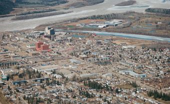
New towns are a specialized aspect of planning. The term refers to the comprehensive planning, zoning and land subdivision of a community, executed before the arrival of any residents. Typically one-industry resource-development towns of small size (fewer than 5000 people), Canada's new towns are mainly located in remote areas (eg, KITIMAT, BC, Matagami, Qué, THOMPSON, Man, and TUMBLER RIDGE, BC).
Most of the early examples (1900-20) were not laid out by planners and did not benefit from imaginative site planning. Adams and others began applying the ideas of Garden City, master plans and zoning to new resource towns in the 1920s (eg, TÉMISCAMING, Qué, KAPUSKASING, Ont, Arvida, Qué, CORNER BROOK, NL, Port Alice, BC). In the post-WWII period, planners of RESOURCE TOWNS began to pay attention to the acute social and leisure activity problems associated with small, isolated and "closed" communities. Further advancements were made in devising new forms for town layout and housing, making these fundamental components of a new town plan more adapted to the rugged site conditions and cold climate environments. A notable recent example of progressive new town planning is Fermont, Qué, designed by Norbert SCHOENAUER and built by the Québec-Cartier Mining Co. The overall plan is compact, and both the street layout and housing construction serve as screens against the harsh winter winds. Many of the single-family houses are oriented for passive solar heating. The town's commercial and entertainment centre is fully enclosed within an extensive building complex that also includes apartment dwellings.
Community Planning and Social Policy
Arguments persist about the appropriate role and purposes of planning as an instrument for social betterment. It is not that the basic goals of efficiency and orderly urban development are under challenge; the real question is whether order and efficiency should be the only goals. In its beginnings in Canada, and in the early American and European reform movements, town planning had offered the promise of something altogether more radical. It was to be part of the antidote to the enormous social costs of the Industrial Revolution, a sweeping movement of social reform in which the building of better cities would contribute to the building of a better civilization. At a more practical, humanitarian level, this meant that each community should assume some obligation to care for the victims of economic development and of the progress of urban industrial areas.
The main impact of these ideas in Canada began to be felt in the 1950s, although there were earlier signs of concern. Prominent social reformers, such as J.S. WOODSWORTH in Winnipeg and Claire Casgrain in Montréal, made no small contribution to the progressive advancement of the Canadian planning movement. It took the Great Depression of the 1930s, followed by the desire for national reconstruction after WWII, however, for housing reform and physical planning to be linked effectively as instruments of social policy.
One of the first indications of this trend appeared in 1935, in the chapter on housing in Social Planning for Canada compiled by the LEAGUE FOR SOCIAL RECONSTRUCTION. The author was a young British-born architect, Humphrey CARVER, who was to become one of the most distinguished Canadian planners. Carver argued that all Canadians had a right to live in safe, healthful, comfortable houses and neighbourhoods, even if they could not afford them, and that the state had a responsibility to ensure that good housing conditions were available to everyone. He argued, as Hodgetts and Adams had done, that it was necessary to build better communities to create a physical and social environment conducive to a decent way of life. Carver's argument was developed further in "Housing and Community Planning," a study released in 1944 as part of the final report of the Committee on Post-War Reconstruction, set up by the federal government in 1941.
This study was largely the work of 2 men, C.A. Curtis, an economist who chaired the housing subcommittee, and Leonard MARSH, the committee's research adviser. In a manner reminiscent of Adams's most famous report, Rural Planning and Development (1917), Curtis and Marsh described the ills of uncontrolled urbanization and slum conditions. They drew attention to the extensive occurrence of wasteful and unsightly suburban developments. They urged the government of Canada to embark upon a comprehensive national program for social betterment and community development, in which housing, planning and public education would figure prominently.
Consequently, in 1944 the federal government made sweeping changes to the National Housing Act to promote the construction of new houses, the repair and modernization of existing houses, and the general improvement of community environments.
In 1946 the Central Mortgage and Housing Corporation (now CANADA MORTGAGE AND HOUSING CORPORATION) was created to implement the new national housing policy. This policy was subjected to further refinement over the next 20 years or so, through a series of amendments to the National Housing Act (NHA), which provided a major spur to urban planning activity in the postwar period. For the first time there was a national planning agency with strong regulatory and financial power. Through its role as an insurer of residential mortgages CMHC exerted a great deal of control over the design of Canadian suburbs (seeDEVELOPMENT INDUSTRY). Through its direct grants for housing for low-income families and other disadvantaged groups, CMHC has influenced the social geography of Canadian cities. And through its various urban renewal programs, from the slum clearance and redevelopment schemes of the 1950s and 1960s to the neighbourhood rehabilitation projects of the 1970s, CMHC has been a major force for environmental change in inner-city areas. Since 2009, social housing projects across Canada have been able to access funding for renovation and retrofit projects.
CMHC's policies and programs have generated their own share of controversy over the years, but the NHA has always held a clear social objective: all Canadians should have access to a decent standard of housing. The "decent standard" must be defined by society, while the community at large assumes part of the cost of raising everyone's environment to an acceptable condition. This principle is well accepted in Canada today and underlies numerous social programs of federal and provincial governments alike. Yet the question arises: Is physical planning (and land use regulation) a proper instrument for redistributive purposes? On the one hand, the provincial planning statutes largely ignore the issue; their statements of purpose are usually limited to "the economical and orderly development of land," or some such phrase. On the other hand, in the actual planning decisions that are taken, day in and day out, questions of rights and justice are constantly in the forefront, and many Canadian communities have adopted physical planning policies that indeed serve redistributive ends. In general, though, Canadian planners are still struggling to reconcile the social reform ideals that were such a powerful force at the turn of the century with the simpler notion of "proper" use of land.
Planning Profession and Education
With the growth of cities after 1945, the Canadian planning profession was revitalized and developed quickly. It is not just that planners were needed in greater numbers than before; the specialized tasks performed in modern planning agencies became far more diverse. In addition to the traditional principles of city layout, land subdivision and architectural arts, planners had to learn about urban sociology and human behaviour, management sciences, data analysis and forecasting, municipal and planning law, and environmental sciences.
Educational programs were established after 1947, for which the federal government and CMHC provided invaluable assistance. In 1944, Marsh and others suggested to the deputy minister of finance, W.C. Clark, that provision be made in NHA to fund research, professional training and public education. Clark inserted a Part V into the Act, entitled "Housing Research and Community Planning."
NHA funds were also used to help introduce degree-granting planning programs in the universities, partly by grants to the first planning schools: McGill (1947), Manitoba (1949), British Columbia (1950) and Toronto (1951). A French-language program was commenced at Université de Montréal in 1961. Several other universities introduced planning programs in the 1960s and 1970s, and in 2009, 15 universities offered major programs in urban planning.
Initially, when urban or civic design was emphasized in the planning curriculum, architects and engineers made up the majority of planning students. This pattern changed as planning programs underwent transformations in social outlook and professional scope. By the late 1950s training in one of the social sciences (eg, geography, sociology or economics) became an equally common route into planning, and this background was further expanded to include the managerial and environmental sciences in the 1960s and 1970s.
In 1949, 45 persons practised planning in Canada. In 1998 the Canadian Institute of Planners counted over 4600 members. In 2009 there were approximately 7000. They serve in many roles encompassed by private consultancies, various departments of the provincial and federal governments, municipal and regional authorities, crown corporations, resource industries, and the land development industry. Two years of supervised work experience after obtaining a planning degree are required for admission into the profession. The CIP is a national affiliation of institutes, 1 representing the Atlantic provinces and 1 in each of the remaining provinces. Besides regulating the professional conduct of its members and supervising standards of practice, the institute carries out programs of public education, and occasionally advises governments on legislation and environmental issues. Approximately one-third of the institute's financial resources go to support a professional journal, Plan Canada. Many of the provincial affiliates of the CIP publish a journal on current planning matters (eg, the Ontario Planning Journal).
WILLIAM T. PERKS Revised: GEOFFREY SIMMINS
Urban Planning, 1980s to the Present
Urban planning since the 1980s has been characterized by increasingly diverse theoretical perspectives. In contrast to modernist urban theory, which sought universal applications, contemporary urban planning embraces particularity, individuality and regional diversity.
Two seemingly intractable and contrasting issues dominate recent urban planning theory and practice in Canada. The first is how to modify existing cities, particularly downtowns, so that they are serviced more effectively by public transportation and offer both cultural amenities and accommodation. The second is how to plan suburbs so as to be more livable. With respect to downtowns, many Canadian cities have worked diligently since the 1980s to improve both public transportation as well as cultural amenities. While Montréal and Toronto both deserve mention, and even spread-out Calgary has taken steps to improve its downtown amenities, perhaps the most successful of Canadian cities is Vancouver, which has not only built an elevated public transportation network (Skytrain) but increased density in its downtown while reclaiming disused waterfront areas in both False Creek and Burrard Inlet. The Coal Harbour district of Vancouver, criticized by some for its expensive condominiums, nonetheless has become a vital and popular area, competing with Granville Island for tourists.
"New Urbanism" is perhaps the single largest trend in planning since the 1980s. Originally developed in the US in such communities as Seaside, Fla, new urbanism asserts traditional town-planning values such as walking, small-scale buildings, and facades and materials subject to strict design controls. Although such communities are often livable, some scholars criticize them for their artificiality and the extent to which they are controlled. Some critics, notably the American writer and futurist James Howard Kunstler, go even further and decry any efforts to improve suburbs, writing that doing so means committing "the greatest misallocation of resources in the history of the world." New urbanist communities in Canada include the Cornell Park district of Markham, Ont, and McKenzie Towne in Calgary, Alta. In such communities, cul-de-sacs preferred by early 20th-century suburban planners have largely been replaced by traditional grid plans strategically punctuated by public amenities and shopping. Other characteristics of new urbanist communities include the reintroduction of back lanes (so that garages are removed from the front), pathways for pedestrians, and town amenities within walkable distances. The extent to which such communities become isolated from the larger communities that they are peripheral to remains an issue.
Scholars continue to be interested in the practice and theory of urban planning and the issues are very relevant, given the number of Canadians who live and work in cities and their suburbs. As Larry S. Bourne noted in a 2007 research report, "At present, more than 80 percent of Canadians live in urban areas, occupying a mere 5 percent of the nation's vast land surface, and over 57 percent live in the five largest urban regions."
Scholars such as Jill L. Grant of Dalhousie University examine questions such as theory and practice in planning the suburbs, including issues relating to public versus private realms, with the overall goal of exploring what constitutes a "good community." University of BC planning professor Leonie Sandercock invites even broader perspectives including feminism, multiculturalism and what Sandercock terms "mongrel cities," signifying trends that are pluralistic, vital, yet democratic.
Urban planning is taught as a major field of study at 15 different Canadian universities. Many Canadian urban planners - 7000 professionals in the field at present - are members of the Canadian Institute of Planners.